
The motivation for developing Image Provenance to Learn (Ip2Learn) comes from academic, government and industrial collaborations that involve development of new computer methods and solutions for for provenance information gathering. The main driver behind the Ip2Learn development was information gathering about decision processes using geospatial electronic records and the need to perform quantitative evaluations of computational cost versus information granularity tradeoffs of information gathering. We envision the use of Ip2Learn also for auditing and quality control purposes as well as for education and training purposes.
Ip2Learn consists of two main parts:
- The first part is the image inspection tool represented by a frame with a simple menu; and its content represented by an image
panel.
The image inspection tool allows users to load and manipulate images (zoom, crop, subarea view, band selection, image information, annotation, grayscale view, and gamma adjustment). - The second part is the tool that gathers image provenance information, provides real-time visualization, and allows changing the provenance gathering settings.
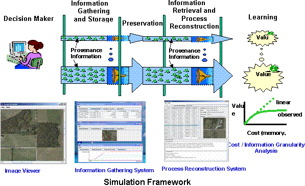
Figure 1: Sketch of the Image Provenance to Learn simulation framework
Image Provenance to Learn was created at the National Center for Supercomputing Applications, University of Illinois at Urbana-Champaign. We would like to acknowledge NARA and NCSA for the support.
Team members
The main creators of Ip2Learn are Rob Kooper and Peter Bajcsy.
