Recent development of advanced hyperspectral sensors has enabled better class discrimination of objects due to a higher spectral resolution than one could achieve with standard electro-optical (EO) and infrared (IR) sensors.
Hyperspectral image analysis has been applied in several Geospatial information systems (GIS), systems for capturing, storing, analyzing and managing data referenced to the Earth. Hyperspectral sensors generate imagery that captures surface and sub-surface properties of objects, e.g., fine textured soils and provide non-invasive and nonintrusive reflectance measurements.
Potential applications include:
- Environmental monitoring
- Sensor design
- Agriculture and forestry
- Security
- Cartography
- Military
Common problems in the area of hyperspectral analysis involving data relevancy include
optimal selections of wavelength, number of bands, and spatial and spectral resolution.
Additional issues include the modeling issues of scene, sensor and processor contributions to the measured
hyperspectral values, finding appropriate classification methods, and identifying underlying mathematical models.
Every problem formulation is usually also associated with multiple application
constraints. For example, communication bandwidth, data storage, discrimination or
classification accuracy, minimum signal-to-noise ratio, sensor and data acquisition cost
must be addressed.
Acknowledgements
This material is based upon work partially supported by the National Center for Advanced Secure Systems Research (NCASSR), and the National Laboratory for Advanced Data Research (NLADR). The authors also thank the United Soybean Board and the Illinois Council of Food and Agricultural Research for their financial support. Finally, this project was also supported by the National Institute of Health and National Center for Supercomputing Applications.
Analysis of Hyperspectral Images
Part of this project is a development of a new methodology for hyperspectral band and method selection using unsupervised and supervised methods driven by classification accuracy and computational cost. The problem is formulated as follows: Given N unsupervised band selection methods and M supervised classification methods, how would one obtain the optimal number of bands and the best performing pair of methods that maximize classification accuracy and minimize computational requirements?
Unsupervised methods for band selection: Unsupervised methods order hyperspectral bands without any training and the methods are based on generic information evaluation approaches. Unsupervised methods are usually very fast and computationally efficient. These methods require very little or no hyperspectral image pre-processing. For instance, there is no need for image geo-referencing or registration using geographic referencing information, which might be labor-intensive operations
- Information Entropy
- First Spectral Derivative
- Second Spectral Derivative
- Contrast measure
- Spectral Ratio Measure
- Correlation Measure
- Principal Component Analysis Ranking (PCAr)
Supervised methods for band selection: Supervised methods require training data in order to build an internal predictive model. A training data set is obtained via registration of calibrated hyperspectral imagery with ground measurements. Supervised methods are usually more computationally intensive than unsupervised methods due to an arbitrarily high model complexity and an iterative nature of model formation. Another requirement of supervised methods is that the number of examples in a training set should be sufficiently larger than the number of attributes (bands, in this case). If taken alone, the unsupervised methods can, at best, be used to create classes by clustering of spectral values followed by assigning an average ground measurement for each cluster as the cluster label. Supervised methods therefore provide more accurate results than unsupervised methods.
- Regression
- Instance based (k-nearest neighbor)
- Regression tree algorithms

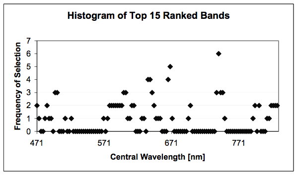
Histogram of top 15 ranked bands by all unsupervised methods.
The hyperspectral image data used in this work were collected from an aerial platform with a Regional Data Assembly Centers Sensor (RDACS), model hyperspectral (H-3), which is a 120-channel sensor developed by NASA.
Hyperspectral Imagery for Band Selection in Agricultural Applications
Precision farming practices are conceptually based on within−field variability information. Modern sensing technologies including remote sensing for information gathering results in large volumes of raw data. Remote sensing can provide high−resolution data on geospatial variability in yield−limiting soil and crop variables. It can be used for mapping soil characteristics, leaf area index (LAI), crop development, canopy coverage, pest infestation, plant water content, and crop stresses Lack of data mining tools and inability of agriculture producers and consultants to extract useful information from large volumes of raw data on yield−limiting factors is a major hurdle in the widespread application of remote sensing at production level.

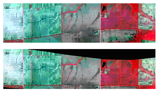
A raw image of field 1: (a) platform−based image distortion, and (b) after correcting for error caused by platform roll.
In our project we propose methods for unsupervised and supervised band selection and their application to hyperspectral data collected for precision farming.
The experimental data set used in this study came from a series of images taken over the entire growing season that
were collected to study the relationship between hyperspectral information and both bare soil properties before
crops had emerged and crop properties when they were present.
The images were pre-processed to correct for geometrical distortions, calibrated for sensor noise and illumination,
and geo-registered. However, the images were not pre-processed for any atmospheric corrections.


