
Groundwater recharge and discharge modeling
We focused on the problem of modeling groundwater recharge and discharge rates. The phenomena related to groundwater recharge and discharge result from a set of complex, uncertain processes and are generally difficult to study.
There is currently no single method capable of estimating R/D rates and their patterns for all practical applications. Therefore, our joint research focuses on analyses using various estimation methods jointly and by incorporating field information into the analyses.
We provide test data to illustrate how to incorporate and mine slope, soil type and proximity to water bodies for predicting groundwater recharge and discharge (R/D) rate models.
The joint research of NCSA and Illinois State Water Survey (ISWS) combines the computer science and ground water science expertise, and leveraged numerical methods and image processing algorithms to efficiently estimate R/D rates. The results of our joint research help hydro-geologists to better understand zonation delineation. The work in progress is being tested against an intensively studied field site in Wisconsin and it will be applied immediately to several groundwater studies in northeastern Illinois.
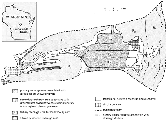
Figure 1: Illustration of a recharge/discharge map of the Buena Vista Basin, Wisconsin.
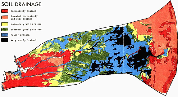
Figure 2: A soil drainage map.
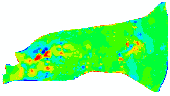
Figure 3: Results of pattern analysis (cell-by-cell recharge estimation) from the above maps.
Spatial Pattern to Learn (Sp2Learn) software presents a framework for accurate estimation of geospatial models from sparse field measurements using image processing and machine learning. Sp2Learn allows users to explore the improvements when several image de-noising techniques, decision tree machine learning techniques and remote sensing and terrestrial measurements are used.
Spatial Pattern to Learn was created as a joint collaboration between the Illinois State Water Survey and the National Center for Supercomputing Applications at UIUC.
Funding support was provided by NCSA Faculty Fellow Program and ISWS, Groundwater division.
Team members:
Yu-Feng Lin
Illinois State Water Survey and University of Illinois
at Urbana-Champaign
Peter Bajcsy
National Center for Supercomputing Applications and University of Illinois at
Urbana-Champaign
Chul Yun Kim
Student in Computer Science Department, UIUC
National Center for Supercomputing Applications, UIUC
Presentation:
Yu-Feng Lin, Peter Bajcsy, Jihua Wang, Albert Valocchi and Randall Hunt,
"Development of Point-To-Zone Pattern Recognition And Learning Utilities For
Groundwater Recharge And Discharge Estimation"
The geological society of America, 2006 Annual Meeting, Philadelphia 22-25 October 2006.
